Visibility in the Cairngorms
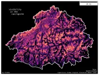
| projection | UTM Zone 30N |
|---|---|
| tools | python: geopandas, matplotlib, osmnx, cartopy, rioxarray, gdal, rasterio.
|
| data | OpenStreetMap contributors, Copernicus Global DEM (ESA) |
| font | Deja Vu Sans Mono |
| comments | I like how this looks similar to the terrain, but it isn't. The dark valleys do an okay job of representing areas that are hidden from hilltop views. A few peak labels wouldn't go amiss |
| date | 20/11/2023 |