| projection |
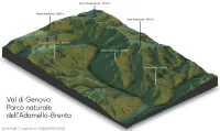
Orthographic: Isometric (i think?)
|
| tools |
Python for getting the elevation data; R rayshader for plotting; and Inkscape for title placement
|
| data |
Elevation data from Copernicus Global DEM (ESA); Peaks from OpenStreetMap
|
| comments |
My first time using the R rayshader library, to render terrain in 3d. I suspect it's a tool that is easy to learn and hard to master. There are lots of options. This was a workout for my aged laptop, and the DEM is only ~30 m resolution. Knock-outs for the leader lines would be better, and perhaps should have done all the labelling in Inkscape after rendering
|
| date |
17/11/2025
|