| projection |
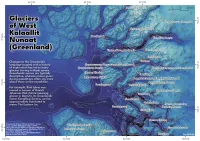
NSIDC Sea Ice Polar Stereographic North. EPSG:3413
|
| tools |
QGIS
|
| data |
Greenland Glacier Names from Bjørk, Anders; Kruse, Lisathe; Michaelsen, Peter (2015), and subglacial topography & bathymetry from BedMachine v5 by Morlighem, M et al. (2022)
|
| font |
League Spartan by The League of Moveable Type
|
| comments |
Manually placing labels instead of letting QGIS decide would have worked a lot better here. Spot the marker that didn't get a label...Because the sub-glacial topography is being shown, and there are many inland areas which have been over-deepened, it's not that obvious where the coastline is, despite that contour being black (which I don't mention anywhere, maybe a basic legend item. Also on the inline contour labels, which are white for values below 0, you can't see the '-' symbol preceding the number: oops.
|
| date |
24/11/2025
|