| projection |
UTM Zone 32N
|
| tools |
Python libraries: geopandas, cartopy and matplotlib; along with QGIS and Inkscape
|
| data |
Elevation data from Copernicus Global DEM (ESA); coastlines and rivers from Natural Earth
|
| font |
Recursive Sans & Mono, by Stephen Nixon, with Lisa Huang, Katja Schimmel. Rafał Buchner & Ben Kiel
|
| comments |
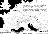
The reasoning behind the harsh black & white styling of this comes from the intention of making this in such a way that the pen-plotter loaded with a 0.5 pilot will produce something nice. Quite like the elevation styling. The elevation profile needed a gratuitous number of buffered strokes so it always had contrast with the background, should probably thin the middle on a bit. Adding labels to this is on the to do list. Just the rivers and a few of the cities along the route? I think so. Is it obvious that the dots are where a I slept? I hope so.
|
| date |
04/11/2025
|