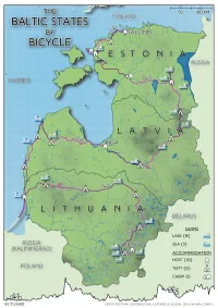
| projection |
UTM Zone 35N
|
| tools |
QGIS, plus a bit of python for wrangling .gpx files and making the elevation profile.
|
| data |
OpenStreetMap contributors; Copernicus Global DEM, ESA; Natural Earth
|
| font |
High Tide Sans by Filipe Rolim
|
| comments |
Apart from the hillshade making the map look a bit dirty, because well, there aren't that many hills over there and I couldn't think of a better way to add texture. Also, not particularly enamoured with the green. I do quite like the stippled sea, and the swimming icons that distinguish sea swims from lake swims. A few too many drop shadows.
|
| date |
05/11/2024
|