Scale Matters
| projection | WGS 84 / Pseudo-Mercator. EPSG:3857 |
|---|---|
| tools | QGIS, only |
| data | Made with Natural Earth |
| font | Redaction by Jeremy Mickel |
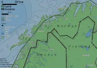
| comments | Nice idea, not the nicest of executions. All of the labels should be a bit bigger, the gray for the borders in the 1:10 million doesn't look great. Dashes of different lengths might work better. The borders and land items in the legend are for polygons, even though I'm only showing the exterior lines here, so these symbols should really just be lines instead of empty boxes. Love the font, though. |
| date | 22/11/2025 |