| projection |
OSGB
|
| tools |
Python: matplotlib, cartopy, xarray, geopandas, shapely and scipy for the KDTree
|
| data |
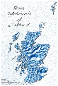
Catchment Boundaries for Soctland based on Scottish Environment Protection Agency catcments (includes Crown copyright, Cefas 2023), Coastline from OpenStreetMap
|
| font |
League Script by the League of Moveable Type
|
| comments |
Distances to catchment boundary were created across a 0.5 km grid. A hillshade was then applied to the resulting proximity surface. Merging some of the smaller catchments would probably aid legibility here. Better still, find the North Sea / Atlantic water shed and get distance from that boundary, and hillshade the proximity to that.
|
| date |
20/11/2025
|