Retro Hardangerjøkulen
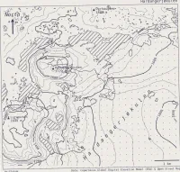
.png, then re-imported to add some blur, random noise, and rotate it slightly. With the goal of making it look like it had been photocopied. Inspired by figures published in the Journal of Glaciology before my time. For more details. This was made for Day 11 of the 2023 #30DayMapChallenge: Retro.
| projection | UTM Zone 32N |
|---|---|
| tools | python: geopandas, matplotlib, osmnx, pystac, xarray, rioxarray, scipy.
|
| data | OpenStreetMap contributors, Copernicus Global DEM (ESA) |
| font | Deja Vu Sans Mono |
| comments | Reasonably pleased with how this one turned out. Knock-outs around the texts would greatly improve legibility; lakes should probably be labelled; the symbology of lakes (diagonal hatching) and ice cap (stippled) could perhaps be swapped, and the hatch density decreased |
| date | 11/11/2023 |