| projection |
?
|
| tools |
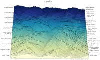
python: geopandas, matplotlib, xarray. With plenty of custom functions
|
| data |
Copernicus Global DEM (ESA)
|
| font |
Deja Vu Sans Mono
|
| comments |
An attempt at a ridgeplot. Not wholly convinced the colour map works. Getting the lines from the labels not to cross was fiddly; my fondness for all lowercase makes the title look silly; fewer leader lines and some labels directly on the map might look better; an icon of a mountain hut instead of a square could work better, but might look a bit cluttered
|
| date |
10/01/2024
|