# tlohde

Figure 1

A satellite image showing a few outlet glaciers in west Greenland. Two are labelled: In orange: Kangaasarssup Sermia (KS) and in blue Isortuarsuup Sermia (IS). An inset shows a close up of the terminus of IS where ice bergs can be seen in the lake.
Figure 1: (a) The lake-terminating Isortuarsuup Sermia (IS) and land-terminating Kangaasarsuup Sermia (KS) with their respective centrelines (solid lines) and runoff catchments from Mankoff and others (2020) (dashed lines). Ice surface contours at 250 m intervals generated from BedMachine v5 (Morlighem and others, 2022); background image: Sentinel-2 acquisition from 19 September 2022 (ESA Copernicus, 2022); Location of study area, south-west Greenland, shown by pink box in inset (upper right). Dashed red box at terminus of IS denotes extent of (b); (b) terminus region of IS illustrating the trim-line (white arrows), terminal moraine (black arrow), grounded icebergs (orange arrow). Sentinel-2 acquisition from 18 September 2019 (ESA Copernicus, 2022).

projection 
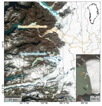
NSIDC Sea Ice Polar Stereographic North. EPSG:3413
tools Python libraries: geopandas, cartopy and matplotlib; along with QGIS
data Sentinel-2 acquisition from 19 September 2022 (ESA Copernicus, 2022)
comments Figure 1 from my paper published in JGlac on Terminus thinning at Isortuarsuup Sermia. With hindsight, the decision to plot a hillshade the illumination azimuth and elevation equal to the solar position at the time the Sentinel-2 scene was acquired was perhaps unneccessary and renders the Satellite Image slightly less crisp and clear. Both glacier labels should be larger
date 01/01/2024